Although the history of Arnavutköy is said to date back to the Trikos Castle, an ancient settlement (which is not mentioned much in historical archives) is found to the east of the Sazlıbosna-Kayabaşı road in the area of Filipos Desertion (Filipos Farm). In this context, the oldest settlement within the borders of Arnavutköy is the ancient city of Filipos, called the Filipos Desertion (Filipos Farm) in east of the Sazlıbosna-Kayabaşı road.
The history of the present-day Durusu (Terkos) district also dates back to 1000 years ago. The district of Çatalca, where the Terkos Lake is located, and its surroundings were an ancient Thracian settlement during the Eastern Roman Empire. Since Terkos and its surroundings have been covered with large forest areas since ancient times, it is known that they were used as an important hunting center during the rules of the Eastern Roman and Ottoman Empires. Built during the Eastern Roman period on the edge of Durusu Lake, Trikos Castle was one of the front defense lines of Istanbul. The castle fell into the hands of the Genoese, and eventually conquered by Mehmed II. (the Conqueror) in 1452.
Arnavutköy had one of the main water supply pipelines to Istanbul during the late Roman period. It is believed that Roman Emperor Constantine started the construction of the water supply line, and it was later continued and completed by the subsequent rulers. The water supply line is considered to have started from Kırklareli's Vize district and it is thought to have had a length of 242 km. The water supply line passed south of Lake Terkos via Vize, Saray, Istranca, Aydınlar, Gümüşpınar, Çiftlikköy, Kalfaköy and Dağyenice and reached Tayakadın. It continued from the right bank of Alibeyköy Creek, passing Cebeciköy and Küçükköy and entering the city about 200 m south of Edirnekapı. There are about 40 aqueducts on the water supply line that are still half ruined or only the foundations remain. The water supply system had been used continuously for about 1000 years; however it was probably abandoned in the XII century due to the damage caused by earthquakes.
During its rule, the Ottomans often encountered problems in Lake Terkos meeting the water needs of Istanbul. The weirs of the Terkos were cloudy and had a foul smell, causing enteritis among people. Later, its waters were cleaned and maintenance and repair were provided for the weirs. The waterways were replaced with iron pipes and to overcome the problem. In addition, the Medical School run certain tests and found infectious and microbial diseases in Terkos water. Thus, the public was informed not to drink and use it without filtering and boiling. In addition to these measures, a military unit was assigned to prevent foreign substances from entering the Terkos water.
Considering that the main reason for the water shortage that Istanbul suffered from was due to the deterioration of waterways, the authorities were convinced that raising the embankments and increasing the waters would not provide the expected benefit unless their maintenance and repair were made. Thus, it was decided to establish a valve and pump station. A tramline was constructed between Terkos and Karaburun to facilitate the transportation of the tools and instruments needed for the construction of the waterway, and a set and pier were constructed in Karaburun, demonstrating the extensive effort to solve Istanbul's water problem by Terkos' waters.
In order to meet the water needs of Istanbul, an elevation center and a pumping station were built on the shore of Lake Terkos between 1855 and 1857; the Terkos Water Company purified the supplied water and started supply the water to the city. These facilities were converted into a "Water Museum" by the Istanbul Water and Sewerage Administration.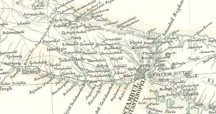
Terkos and its environs met the water needs of Istanbul during the Ottoman period, as well as being the supply center for the timber needed for constructing the navy on the Imperial Arsenal. A navy was built with the timbers supplied from the regions of Terkos, Çatalca, Silivri, Büyükçekmece, Midye, Saray, Vize and Pınarhisarı.
The name Arnavutköy (Arnautköi) appears in the Ottoman archives and maps of the time since the middle of the 19th century. It is believed that an Albanian peasant who lived in this region in ancient times was the namesake father of Arnavutköy. As a matter of fact, the region had been located in the route to Edirne and therefore to Europe since its earliest periods. Due to the fact that it was located on the main road and an Albanian lived here, those who passed by this route called this place the Albanian's Village over time. This name changed over time first to "Arnavutköyü (the Village of the Albanian)" and then to "Arnavutköy".
There have been three major changes in the population of Arnavutköy and its surroundings in the last century. The first of these took place with the emigration from Bulgaria, Kosovo and Macedonia during the Balkan Wars. As a matter of fact, migrants and refugees from Demirhisar, Toyran, Thessaloniki, Tikveş and Priştine had been resettled in the villages of Terkos, Tayakadin and Imrahor after the Balkan War.
The second major change in the population of the region occurred at the end of the Population Exchange Treaty signed between Turkey and Greece in 1923. Along with the exchange, the Turks in the Greek province of Drama were resettled in Arnavutköy and the surrounding villages. After the exchange, the number of households in Arnavutköy reached 350.
The third major change occurred in the process after Arnavutköy became a town. Over the years, Arnavutköy has been affected by the domestic migration moves throughout Turkey and has become an increasingly large center.
Arnavutköy was connected to Çatalca District during the Ottoman period and then it was annexed to Çatalca Town. During the Republican period, it was first a village connected to Eyüp District, and when Gaziosmanpaşa became a district in 1963, it was annexed to this district, and in 1987, it gained the status of a town connected to Gaziosmanpaşa District. Hadımköy and Durusu within the borders of today's Arnavutköy gained the status of towns in 1969 and 1989, respectively, while Boğazköy, Bolluca, Haraççı and Taşoluk became towns in 1994.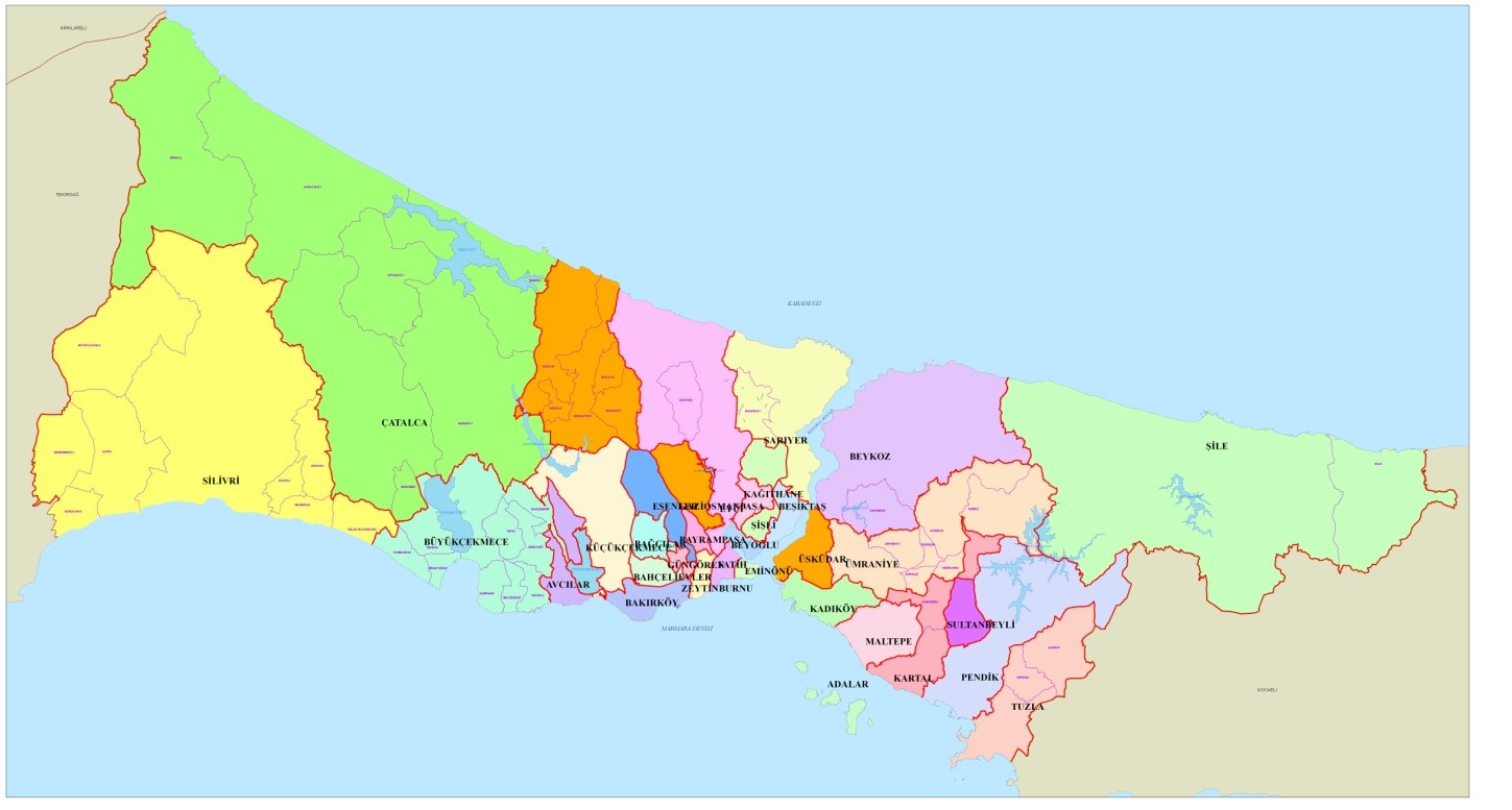
The towns of Boğazköy, Bolluca, Durusu, Haraççı, Hadımköy and Taşoluk were annexed to Arnavutköy Municipality by "the Law No. 5747 on the Establishment of Districts within the Boundaries of the Metropolitan Municipality and Amendments to Some Laws". In addition, Bahşayış Neighborhood annexed to Çatalca and 8 forest villages within the boundaries of Çatalca and Gaziosmanpaşa as well as the north of Sazlıdere Dam Lake of the Şamlar Village belonging to Küçükçekmece District were annexed to Arnavutköy
The newly established Arnavutköy District became one of the 39 districts of Istanbul, while the entire territory of the district is now recognized as the service area of the Arnavutköy District Municipality. While Arnavutköy had been part of Gaziosmanpaşa for about 45 years, it thus became a separate district. With a total area of 506.52 km², the district is now the fourth largest district of Istanbul.
After the Law No. 5747 entered into force, the legal entity status of all other villages, with the exception of forest villages located within the boundaries of Arnavutkoy District, was abolished and they were turned into a neighborhood. The villages that have preserved the status of forest village are: Baklalı, Balabanburun, Boyalık, Hacımaşlı, Karaburun, Tayakadın, Yassıören and Yeniköy.
Nakkaş (46,78 km²) and Bahşayış (9,46 km²) neighborhoods were annexed to Arnavutköy with law no. 5747, and then to the Province of Çatalca with the "Law No. 6360 on Establishment of Metropolitan Municipalities and 26 Districts in Thirteen Provinces and the Amendment of Certain Laws and Decrees having the Force of Law". Thus, the area of the district decreased by 56.24 km² and became 450.28 km². Despite this, Arnavutköy has maintained its position as the fourth largest district of Istanbul.

About Arnavutköy
-
History of Arnavutköy
4 year ago -
Arnavutköy by Numbers
4 year agoCities have been competing against time and other cities over time, and our city has been continuing to grow and flourish with its claim of being the city that lives and offers life.
As we wish Turkey and our city become important attraction centers in the world today, it is of great importance to correctly plan the future so that our city continues to progress with firm steps.Total Population 312.023 Number of Neighborhoods 38 adet District Area 481.89 km Lake 29 km Number of Streets 394 adet (1 adet bulvar) Street Length 636.500 m Number of Streets 4149 adet Street Length 952.100 m Number of Main Arteries 64 adet Length of Main Arteries 223537.57 m -
Geographical Structure and Vegetation
4 year agoArnavutköy is at the intersection of the subtropical high pressure belt and the low pressure belt of the cold-warm region, or the terrestrial (moisture-free) trade winds and the marine (humid and rainy) west winds. Different climatic conditions occur in winter and summer seasons with the motion of the earth.
Since Arnavutköy District is located on the Black Sea coast, it features the Black Sea climate and the Mediterranean climate through the Marmara Sea. There is no possibility to evaluate the climate type in the area where Arnavutköy is located with a specific climate type only. By the nature of its geographical location and physical geography characteristics, it has different climatic characteristics than the climate of many settlements located at the same latitude.
There are three major weather types in Arnavutköy. These are calm weather types introduced from the north and south. Among the three types of weather, the one that shows the highest frequency (the highest number of blows) is the type of weather that is observed when the northern winds prevail. Arnavutköy District is located in a temperate climate zone with warm and rainy winters and hot summers. Considering that the topography and the water resources near it directly affect the climatic conditions in Arnavutköy District, it can be said that a transitional climate prevails here.
The temperature decreases in Arnavutköy when moving inland towards the Black Sea coast. The average annual temperature of the district is 14.2°C. The warmest months in the district are June, July and August, while the coldest months are January and February. The highest temperature is in July with an average of 23.8°C. The month with the lowest average temperature is February with 5.6°C (See: Table 1).
Table 1: Average Monthly Temperatures of Arnavutköy District (°C)Meteorological Station
Months Annual
Jan. Feb. March. April. May. June. July. Aug. Sept. Oct. Nov. Dec. Florya
5,9 5,6 7,4 11,8 16,4 21,2 23,8 23,6 20,1 15,8 11,2 7,8 14,2
The average rainfall of Arnavutköy District is 648.4 mm. This level is lower than the average rainfall of the coastal areas (about 1,000 mm), however it is more than the average in Turkey (about 220 mm). It can reach 864 mm around Karaburun and Yeniköy in the coastal parts of Arnavutkoy District facing the Black Sea. The highest precipitation is in November, December and January. The lowest precipitation, on the other hand, is in July and August (See: Table 2).
Table 2: Average Monthly Precipitation Values of Arnavutköy District (mm)Meteorological Station
Months Annual
Jan. Feb. March April May. June July Aug. Sept. Oct. Nov. Dec. Florya
82,2 63,2 54,8 50,7 28,9 30,9 24,9 25,2 31,2 70.5 84,3 101,6 648,5
Although wind is an important meteorological parameter, it is very difficult to analyze this parameter since its characteristics show significant changes depending on time, location and altitude. The average annual wind speed in Arnavutköy is generally high on the Black Sea coast. The prevailing wind is the northeast wind blowing from the northeast direction.
As a result of the joint work by Istanbul Technical University (ITU) and Istanbul Water and Sewerage Administration (ISKI), the Storage Reservoir of Karaburun, Durusu-Terkos, Tahlisiye Area is fit to generate electrical energy from wind power.
The landforms determine the character of the vegetation in Arnavutköy, where all the features of the transition climate between the Black Sea and the Mediterranean climate types. Some natural reasons such as the increase in the amount of precipitation towards the northern part of Arnavutköy and the slight change in soil formation conditions have led the forests spreading in these areas to acquire the character of moist forests. Tree species in humid forests include beech, common oak, sessile oak, Istranca oak, field maple, hornbeam, chestnut and linden tree.
According to the 1/100.00-scale Istanbul Environmental Layout Plan, 57% of the district's territory (259.4 km²) appears as a forested area, however about half of it consists of well-protected areas today. The remaining part is mainly maquis shrubland, degraded forest lands or areas that have lost their forest quality. Such areas, on the other hand, are either used for agricultural purposes or are occupied by settlers.
The Terkos dunes are the largest and most important dune system found in Arnavutköy with international importance since they contain many species that are endemic to the region. There are endangered species in these dunes under the Berne Convention. According to the Berne Convention, a route change was made during the construction of the Arnavutköy-Şamlar highway to protect the plant Centaurea Hermannii (Çatalca Cornflower), a rare and endemic plant that is pledged to be protected where it is located.
Arnavutköy-Şamlar Reforestation is an important Wildlife Protection Area. There are ducks and wild geese in Lake Terkos, and wild boars, foxes, jackals, woodcock, pheasants and wild pigeons in forests. There are also buffaloes that have been separated from their herds and have become wild over time.
Forests are concentrated in the south-east, north and north-west of the district. Although records show over half of the district's territory (52%: 259.4 km²) as forest areas, only about half of it consists of well-protected areas today. The remaining part is mainly maquis shrubland, degraded forest lands or areas that have lost their forest quality. Such areas, on the other hand, are either used for agricultural purposes or are occupied by settlers.
The agricultural areas in the district consist of two parts as "absolute" and "marginal" agricultural areas. More than a third (35%: 176.4 km²) of the district's territory is agricultural land. These areas are concentrated in the south, west and central parts of the district. These regions have the form of slightly undulating plains. In addition, there are agricultural land plots among the forested areas. -
Regional Ground Structure
4 year agoArnavutköy is located on the Çatalca Peninsula. Çatalca Peninsula is physically separated by streams and has hills in some places. Having an average height of 150-200 meters, these hills exhibit a plateau feature. The surface shapes of Arnavutköy consist of undulating plains, small hills, valleys, lakes, dams, ponds, mines, agricultural areas, woodlands and maquis shrublands. The territory of the district consists of hilly and undulating plains in the northern and eastern regions, and slightly undulating plains in the southern and western regions. In the north-east of the district, dozens of ponds formed by old stone, sand and mines are located in the area stretching to the Black Sea. Lake Terkos, located in the district, lies parallel to the Black Sea coastline on the edge of a hilly terrain at an altitude of 100-150 m. There are undulating plains around the lake and high sloping hills, the heights of which gradually increase towards the west. In general, a less rugged morphology is observed around the lake. The forested area and coastline between Terkos and Kasatura are a natural habitat of ecological and biological importance. Terkos Lake and its surroundings are an important bird nest throughout the country. In addition, Terkos forests are one of the three forest areas in Istanbul that meet international criteria (Istanbul Provincial Environmental Layout Plan, p. 116). The area of 5790 hectares around Lake Terkos is also a protected forest are (Istanbul Provincial Environmental Layout Plan, p. 127). Lake Terkos is also one of the three wetlands in Istanbul.
3 of the four ecological corridors in Istanbul travel through the Arnavutköy district from north to south. These are the Büyükçekmece-Terkos, Küçükçekmece-Terkos and Golden Horn-Terkos corridors. These function as Istanbul's wind pipes. On the other hand, biological diversity should reach the city by ensuring the functional connection of green areas and forests through ecological corridors. The number of urban structures should be kept low where these corridors pass, and it is necessary to ensure urban air circulation using urban design methods along with the designated open and green areas. In the north of the district, the coastal line between Lake Terkos and the Black Sea shows a coastal type with partly steep cliffs and partly beaches. Looking at the main materials forming the soils around the lake, one can see a structure inclined to erosion.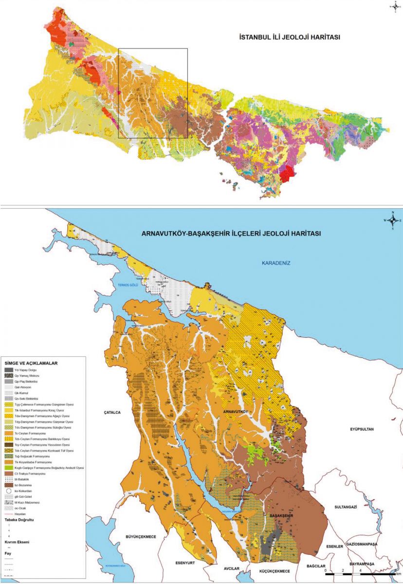
Erosion is studied under two headings: water and wind erosion. The dominant form of erosion in our country and in Istanbul is water erosion. The areas of mild erosion in the lands of Istanbul province are 205.147 ha. It is an area constituting the majority in the country with 49%. These areas are mainly clustered in the northern parts of the Anatolian Side and the north-northwestern parts of the European Side. The areas of moderate erosion are 158,491 ha. and they account for 38% of Istanbul and 11% of the lands are under the influence of severe erosion. There are very few (2%) areas exposed to very severe erosion. The areas with very severe erosion are the coastal areas of Arnavutköy District along the Black Sea coast, as seen on Map 9.
Entering into force with the decision no. 96/8109 of the Council of Ministers on April 18, 1996, the Earthquake Zones of Turkey shows the earthquake evaluation of Istanbul and its surroundings. Accordingly, the vast majority of the Arnavutköy District is a 3rd degree (low risk) earthquake zone according to the general categorization based on geological and geophysical principles.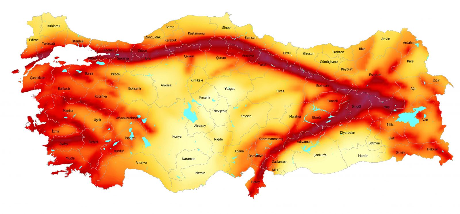
Earthquake risk maps show the impact of earthquakes waves only by regions. An important aspect to note is the fact that the earthquake magnitude increases depending on the structure of the local soil. In other words, two different places located in the same region will feel the earthquake at different intensities according to their soil structure. From this point of view, it can be said that the stream beds and the slopes with landslide potential are especially risky areas in Arnavutköy. -
Neighborhoods
4 year ago -
Layout
4 year agoThe total population of Arnavutköy district is 282,488 people. Although the residential areas in the district show a scattered structure, people are densely settled in the east of the district. The total population of Arnavutköy, Bolluca, Boğazköy, Haraççı and Taşoluk settlements located in the east of the district is 171,868 people as of 2019, making up 80% of the total population.
Hadımköy settlement is located in the southwest of the district and Durusu-Karaburun is located in the northwest. Arnavutköy, Bolluca, Boğazköy, Haraççı and Taşoluk settlements developed over time and turned into collective centers, while Hadımköy, Durusu, Karaburun and other neighborhood settlements showed a more single-center development model.
The total built-up area of the district is 70 km², which makes up 13% of the total area of the district. A high number of residential settlements are observed in the Central District of Arnavutkoy, and structures with 4 to 6 floors are usually observed in these areas. Buildings with 2 to 3-floors are observed in all regions with a low level of build-up in the periphery of the district.
In the areas of Bolluca, Taşoluk, Haraççı, Durusu and Karaburun, there are detached residential settlements that cater to the high income group with low density, developing in the form of closed sites. In addition, mass housing settlements developed in the form of closed sites in the Arnavutköy-Taşoluk-Hadımköy-Ömerli and Deliklikaya regions. -
Water Basins
4 year agoArnavutköy remains in the area of influence of 4 water basins that are very important for Istanbul. These are Alibey Basin, Lake Terkos Basin, Büyükçekmece Lake Basin and Sazlıdere Dam Lake Basin. The Terkos Basin meets 33.5 percent of Istanbul's water needs, Büyükçekmece Basin meets 18.5, Alibey Basin meets 15 percent, and Sazlıdere Basin meets 2 percent of this need. These basins meet 69 percent of Istanbul's water needs in general.
In addition to providing water to the city, the basins in Arnavutköy District also serve as the air corridors of the city. The water corridor in the Sazlıbosna Basin connects the Sazlıbosna Dam to the Black Sea, thus forming a natural airflow corridor. The Alibeyköy Dam Lake in Alibeyköy Basin, on the other hand, combines the ecological corridor connecting Terkos to the Golden Horn with the northern forests through the Bolluca and İmrahor settlements.
Within the natural boundaries of the water basins, climate, geology, topography, soil, flora and fauna interact with the waters of the basin. Any change in these factors by nature or human impact will affect all the basins. Therefore, they are the areas that must be protected. -
Population Structure of Arnavutköy
4 year ago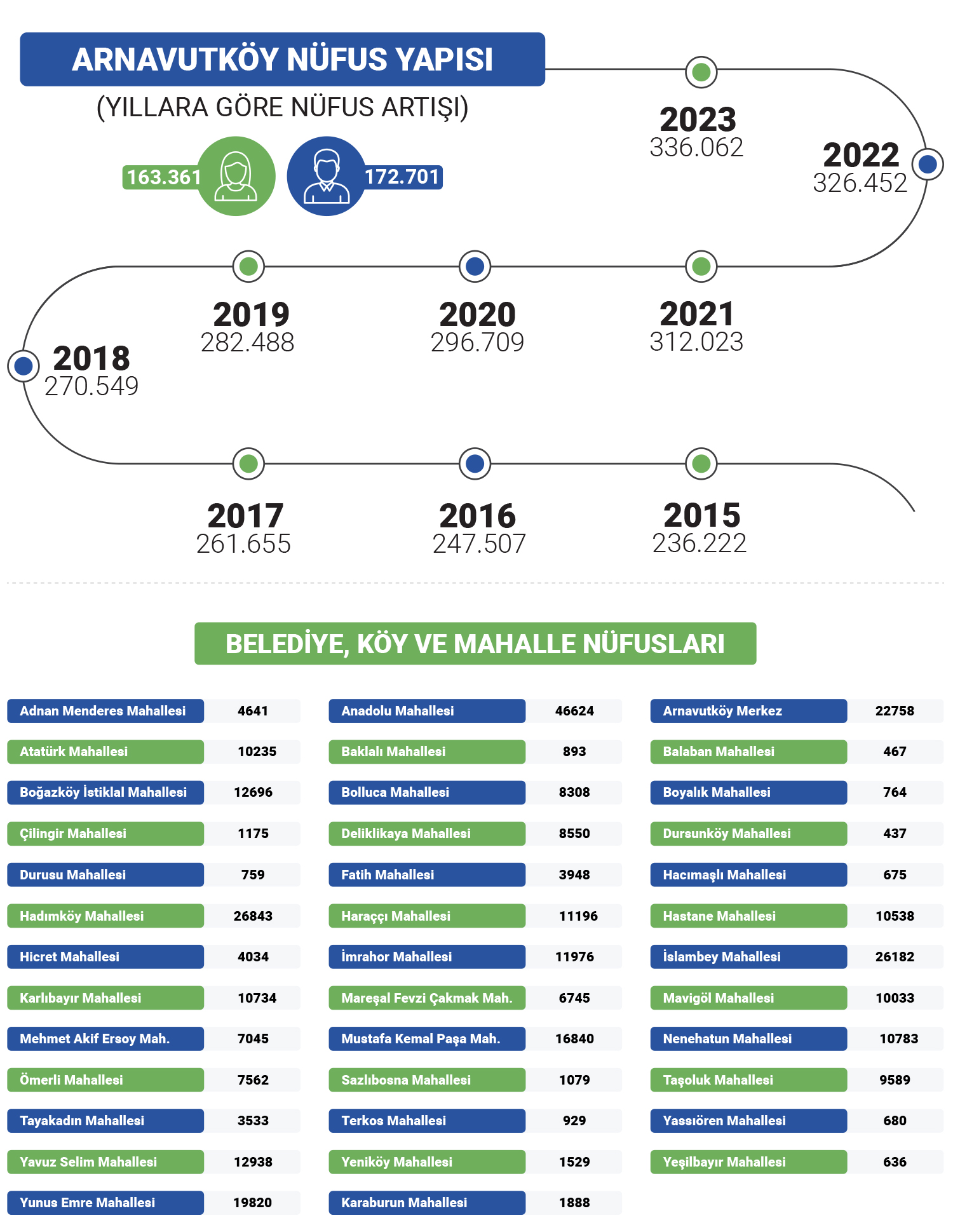
Click Here to Access the Population Information of Arnavutköy. -
Arnavutköy Transportation
4 year agoA study analyzing the competitiveness of the districts of Istanbul found that Arnavutköy ranks 36th among 39 districts in the transportation and accessibility index. Projects such as Başakşehir/Ispartakule/Hadımköy and Hasdal-Karaburun roads, as well as the third airport and the third bridge ring roads (which are ready for the project or are under construction), are important for the accessibility of the district.
It is expected that the third airport project (with finished tender) will completely change the face of the district. The project has increased Istanbul's importance as a transfer point with international flights and various shopping opportunities offered to international transfer passengers with terminals owning a capacity of 150 million passengers. The project covers the Yeniköy, İmrahor and Tayakadın neighborhoods of the district and approximately 12% of the total surface area.
The Istanbul Canal project will make significant contributions to the district's transportation system. Ports and marinas to be built at the northern and southern entrances of the canal, as well as sea transportation means through the canal will add new alternatives to the transportation facilities of the inner regions of the district. In addition, the passage of the canal through the central regions of the district (See. Map 13) and dividing the district into two as the north and south will make it possible to form a second Bosporus Strait.
Arnavutköy is located within the Istanbul metropolitan area, but it is relatively far from the traditional centers of the city. It is about 30 km far from the Fatih-Eminönü axis and 35 km from the Mecidiyeköy-Levent axis. In addition, there is a large forested area between it and Sultangazi, the nearest district center. With this feature, it features as a partially detached area from other settlements in the metropolitan area. Arnavutköy-Boğazköy-Bolluca-Haraççı-Taşoluk settlements at the center of the district are not on the main transportation axes of Istanbul. Only the Hadımköy district is located near the TEM highway. Therefore, it was necessary to develop special lines for the transportation of the district to other centers of Istanbul.
The transportation of Arnavutköy District with other residential areas is provided by bus and minibus lines. There are bus services from the district to Eminönü, Mecidiyeköy, Cebeci, Habipler Metro Station, Gaziosmanpaşa, Fatih, Eyüp and Edirnekapı. Within the district, there are bus services from Karaburun and Hadımköy to Arnavutköy. In addition, there are dolmush and minibus lines to many points in the district, and to Sultangazi, Gaziosmanpaşa and Üçşehitler.
To make transportation to Arnavutkoy faster and more comfortable, the Habipler-Arnavutkoy divided road, built by the Istanbul Metropolitan Municipality, has been completed. The standard of the road, made as a 2x3 lane, is high. In addition, the Habipler-TEM access road has also been opened for transportation as a 2x2 lane. Apart from these, the highway projects that concern Arnavutköy and have been partially/completely built include:
Gaziosmanpaşa-Karaburun Road, Büyükçekmece-Hadımköy Bridge-Yassıören Road, Başakşehir-Ispartakule-Hadımköy Road, Sultançiftliği-Boğazköy Road, Hasdal-Karaburun Road: The rail transportation projects in the district: The Third Airport-Arnavutköy-Kayaşehir-Olympic Stadium-Halkalı-Küçükçekmece Metro Line, Habipler-Arnavutköy Light Metro Line, The Third Airport-Gayrettepe Metro Line and Sabiha Gökçen Airport-Yavuz Sultan Selim Bridge-Third Airport High-Speed Train line.
Click here for Information about Public Transportation and Alternative Means of Transportation to Arnavutkoy District. -
Tourism Potential
4 year agoDurusu-Karaburun axis, forests, lakes, dams and ponds have touristic attraction in the district. The district is important for Istanbul in that it has an opportunity where daily tourism activities can take place. There is also 1 archaeological site within the district. There are fortifications built in the Roman-Byzantine period to stop the incursions of the Hun Turks in the Durusu region.
Considering the general characteristics of Arnavutköy, it has many advantages in terms of natural beauty as well. In addition, it features as an ancient city with a significant number of historical monuments waiting to be unearthed. The vast majority of the district's territory has been preserved, and this increases the attractiveness and importance of the district in terms of tourism. The district also has suitable potential in terms of alternative tourism activities such as water sports, trekking, health tourism and ecological tourism. Considering these factors, it can be said that Arnavutköy is a place open for development both in terms of domestic and foreign tourism.
The set of places where ecological tourism will be concentrated in Arnavutköy district has a total area of 25,140 ha around Lake Terkos. The area covering the villages of Durusu, Baklalı, Balaban, Boyalık, Başakköy, Celepköy, Hisarbeyli, Örencik, Yazlık, Yassıören and Tayakadın neighborhood is located in the northern part of the European side and around Lake Terkos. This area, where ecological tourism will be concentrated, is located in the Terkos, Sazlıdere and Alibeykoy basins.
The region where the mines of Arnavutköy are located on the Black Sea coast is planned to be a recreational and tourism area according to a special project running in an international competition as part of the 1:5000-scale Istanbul Urban Zoning Plan. These areas can be re-arranged for recreational use taking into account the harsh natural characteristics of the Black Sea, provided that materials compatible with nature are used. Marina, boat tourism, boat manufacturing, sheltered local kayak shelters and beaches are among the primary areas of use that can be considered in this regard. Yacht sports areas and wide-ranging, themed "tourist accommodation units" can be made in the ponds near the shore. In addition to culture and congress tourism, forested outdoor areas can also be used for building ecological "natural life themed" parks bringing nature and life together, accommodations, tea gardens, outdoor diners, outdoor refreshment bars, buffets, outdoor washing rooms, tour routes, outdoor sports fields (such as walking, jogging, cycling, shooting), observation terraces, picnic areas, camping sites, play and entertainment parks, botanical gardens and hobby gardens.


-
Hava Durumu17:13 itibariyle, Pzt 31.08.2020 - Hava Durumu Tahmini
-
PazartesiAz Bulutlu
 25°C/15°C
 -
SalıAz Bulutlu22°C/13°C
-
ÇarşambaAz Bulutlu28°C/21°C
-
PerşembeAz Bulutlu31°C/19°C
HAVA DURUMU
17:13 itibariyle, Pzt 31.08.2020 - Hava Durumu Tahmini

Mustafa CANDAROĞLU
President of the Municipality of Arnavutkoy
Mustafa CANDAROĞLU, originally from Cide, Kastamonu, was born on December 5, 1984, in Arnavutköy, Istanbul.
He graduated from Boğazköy Primary School in 1996, Asfa Middle School in 1999, and Sultan Fatih Anatolian High School in 2002. Completing his undergraduate education at the Faculty of Fine Arts of the International Cyprus University, Candaroğlu graduated in Interior Architecture in 2008. He completed his military service as a Short-Term Soldier at the Kayseri Regional Gendarmerie Command. After military service, Candaroğlu completed his master's education in Educational Institutions Management at Ibn Haldun University, and volunteered in various NGOs.
He served as Deputy President of the Arnavutköy Kastamonulular Association, and was a member of the boards of Arnavutköy Sports Club and Arnavutköy Beşiktaşlılar Association.
Being involved in politics throughout his education and social life, Candaroğlu served on the UNIAK Board of Directors in 2004 and actively entered politics in the Arnavutköy Belde Youth Branch in 2008. In Arnavutköy, which became a district in 2009, he held positions in District Congresses as follows: • 2009 as an Alternate Board Member of the District Primary Committee, • 2011 as a Board Member of the District Primary Committee, • 2013 as a Board Member of the District Primary Committee responsible for R&D and Local Governments. • Elected as District President in the 2018 and 2020 Congresses, Candaroğlu continues to serve as the AK Party Arnavutköy District President.
Born, raised, and currently living in Arnavutköy, Candaroğlu always finds happiness in serving in the AK Party, which practices politics based on the principle of "We love the created for the sake of the creator." After working for a long time as an Interior Architect in a family company, he continues to serve as the Chairman of the Board of Directors of Arnavutköy Bilgi Kalem College, which he founded in 2019.
Mustafa CANDAROĞLU, married and father of 3 children, speaks English proficiently.
Content is updating